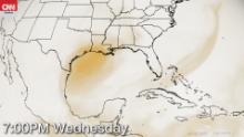
The dust is expected to improve as it moves across Florida this week, but likely to worsen as it reaches the Texas and Louisiana coasts.
The dust will also remain in place for much of the Caribbean and Mexico.
“The concentration of last week’s dust was historic. This week’s dust is much more typical of what we see in any given year,” CNN meteorologist Judson Jones says.
Saharan dust travels to the US every year. It is lifted into the atmosphere by wind and thunderstorms in Africa, as it starts a 5,000 miles journey to the Caribbean and US. This year is the worst in decades.
“By the time the dust cloud reaches the US, most of the larger grains have fallen out due to gravity. What is left is the smallest particles known as PM2.5. They are the most dangerous to breathe into your lungs,” CNN meteorologist Chad Myers says.
However, there are some positive aspects to the Saharan dust. One is limiting the development of tropical systems in the Atlantic due to the dry air surrounding the dust.
Also, it can create some of the most striking sunrises and sunsets. According to CNN meteorologist Haley Brink, “the dust particles high up in the atmosphere can scatter sunlight and create some of the most vivid sunsets.”
The dust should improve by the end of the week.
Source link

Be First to Comment